

U.S. Climate of Troubles: Record Heat Out West, Severe Floods in the East
21
June, 2017
Yesterday
a record heatwave affecting 40 million people cracked pavement,
grounded flights, threatened power grids and risked serious injuries
across the Southwestern U.S. Meanwhile, today, a heavily moisture
laden tropical storm Cindy is threatening to dump 10 to 15 inches or
more of rain on parts of the U.S. Southeast. A pair of opposite
weather extremes of the kind we’ve come to expect more and more of
in a world that’s warmed by about 1.2 C above 1880s averages.
(Very
extreme weather conditions settled over the U.S. on June 20. Today,
Cindy is expected to bring extraordinary rainfall totals to the U.S.
Gulf Coast. Video source: ClimateState.)
Record-Shattering
Western Heat
Yesterday,
the mercury struck a scorching 127 degrees F in Death Valley
California — the hottest June 20th ever recorded for that
heat-blasted lowland. Meanwhile, Death Valley-like heat spilled out
over a large swath of the southwest. Phoenix fell just shy of its
daily record as temperatures struck 119 F. And Las Vegas tied its
all-time record of 117 F (which was set just four years ago on June
30th). Needles, Daggett and Barstow in California joined Kingman in
Arizona and Desert Rock in Nevada to also break previous heat records
as temperatures soared to between 111 and 115 F across these cities
and towns.
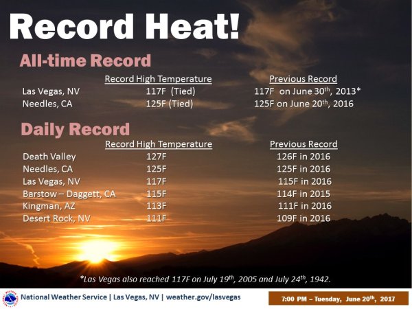
(Record
heat hammered the U.S. West on Tuesday spiking fire hazards,
grounding planes, causing power outages and increasing the risk of
heat injury. Image source: National
Weather Service.)
All
these severe high temperatures took a serious toll as both cities and
citizens fell under blast-furnace-like conditions. In Phoenix, 43
flights were grounded. Aircraft
could not generate enough lift for a safe take-off in the thin,
low-density hot air. Total number flights grounded since Monday now
tops 50 for the city — with more expected Wednesday when
temperatures are expected to hit 118 F.
As
flights were grounded in Phoenix, fires began to spark across the
Southwest. Several fires ignited in Southern California including a
large 950 acre blaze near Big Bear. In Utah,hundreds
of people were forced to evacuate a ski town when a weed-killing
torch ignited a swiftly spreading fire.
And in southwest Arizona, a
wildfire burned 8 structures as more than 100 firefighters rushed to
contain the blaze. Firefighters
across the southwest struggled against some of the most difficult
conditions imaginable — extreme heat, blustery southerly winds, and
rapidly-drying vegetation.
Record
heat also overwhelmed grids when customers cranked up air
conditioning and high temperatures put a major strain on power lines
and transformers. With California temperatures climbing to historic
levels yesterday, power outages were
reported across Central Valley and on
into the Bay area. Extreme
warming of road surfaces caused highways to buckle even as hospitals
prepared for a surge of various heat-related injuries from
burns, to heat exhaustion, to heat stroke.

(Recent
warming of ocean surfaces to well above average ranges off the U.S.
West Coast have likely boosted the development of the recent western
heatwave. Ocean surface warming is a signature condition of
human-caused climate change. Image source: Earth
Nullschool.)
A
strong high pressure system and a large associated ridge aided by
abnormally warm waters off the U.S. West Coast are the primary
regional causes of the most recent heatwave. The pool of warm water
in the Northeast Pacific — somewhat reminiscent of the Hot Blob
that formed in the nearby ocean zones during 2014 and 2015 —
appears to be boosting the development of upper level ridges and
related surface heat over the region as temperatures climb to 10 to
25 F or more above normal for many locations. Despite recent record
winter and spring rainfall for parts of the region, this new heatwave
is starting to again advance drought conditions across the Southwest.
Yet another hard shift in weather extremes from wet and cool to dry
and hot that can likely be linked to climate change.
Cindy
Ushers in Severe Flooding across the Gulf Coast
While
the west scorches under extreme heat, the weather threat to the U.S.
Southeast comes in the form of severe flooding. In the Gulf of
Mexico, a sprawling Tropical Storm Cindy is interacting with a
stalled frontal system to spike moisture levels in the atmosphere
above the U.S. Gulf Coast. Already, between 3 and 9 inches of rain
have fallen over parts of Louisiana, Mississippi, Florida and
Alabama. But the slow-moving, heavy rain bearing Cindy is poised to
dump still more.
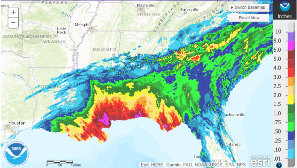
(24
hour rainfall totals show that heavy precipitation in the range of 3
to 9 inches have already fallen across the Gulf Coast. Cindy is
expected to bring even more over the coming days. Image
source: NOAA.)
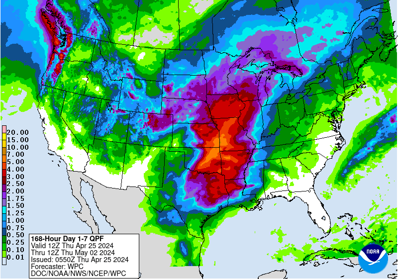
According
to NOAA
QPC predictions for the next week,
as much as 8.5 additional inches of rainfall could impact
already-flooded parts of SE Louisiana. And when all is said and done,
the system is forecast to drop between 10 and 15 inches or more of
rainfall over parts of the area. The storm is not
presently expected to rival last year’s August rain event which
dumped up to 30 inches over the same region.
Of course, with climate change boosting rainfall potentials by
warming the Gulf of Mexico and spiking atmospheric moisture and
instability, the unexpected can certainly happen. Let’s just hope
that’s not the case with Cindy. But 10-15 inch rainfall totals are
certainly disruptive enough. And with some
streets in New Orleans already seeing 2-3 feet of flooding as
more storms rush in from the Gulf, this event is certainly far from
finished.
Links/Credits:
Hat
tip to Suzanne
Hat
tip to Greg
Hat
tip to Tigertown
No comments:
Post a Comment
Note: only a member of this blog may post a comment.